Difference between revisions of "Esplanade East"
Jump to navigation
Jump to search
m (Protected "Esplanade East" ([edit=sysop] (indefinite) [move=sysop] (indefinite))) |
(No difference)
|
Latest revision as of 14:01, 10 June 2012
Easter Bay International Airport |
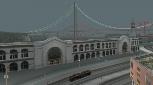
Esplanade East, San Fierro Esplanade East is a district of San Fierro, San Andreas, and rests on the northern section of San Fierro's eastern coastline. It sits atop an engineered seawall on reclaimed land. To the north is Esplanade North and to the south is Easter Basin. To the west is Downtown San Fierro. This is an area frequented by tourists and locals alike. Correspondingly, Esplanade East is a mix of city dwellers and visitors, many of which are enjoying a stroll along the waterfront. This gives the area a relaxed feel and a gentle atmosphere. The Garver Bridge looms overhead, and the cable car line runs along the Esplanade, making for some dramatic city photographs. |
Esplanade North |
| Neighbourhoods and districts in San Fierro, San Andreas |
|---|
| Avispa Country Club • Battery Point • Calton Heights • City Hall • Chinatown • Corvin Stadium • Cranberry Station • Doherty • Downtown • Easter Basin • Easter Bay International Airport • Esplanade East • Esplanade North • Financial • Foster Valley • Gant Bridge • Garcia • Garver Bridge • Hashbury • Juniper Hill • Juniper Hollow • Kincaid Bridge • King's • Missionary Hill • Ocean Flats • Palisades • Paradiso • Queens • Santa Flora |
| Vice City | State of San Andreas | Liberty City (2008) |
|---|---|---|
|
