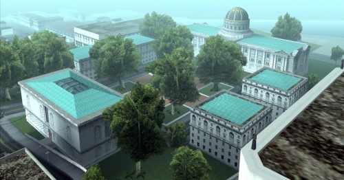
San Fierro City Hall
Revision as of 14:00, 10 June 2012 by Patton (talk | contribs) (Protected "San Fierro City Hall" ([edit=sysop] (indefinite) [move=sysop] (indefinite)))
Calton Heights |
San Fierro City Hall, San Fierro The San Fierro City Hall (known simply as City Hall or SFCH) is located in San Fierro, San Andreas. It is immediately west of the Queens district. North of the City Hall is the district of Santa Flora, while south of the landmark is the district of Ocean Flats. It sits on the western edge of a square plaza surrounded by a road connected to other roads from the north, east, and south. Most pedestrians that can be found in the area are all residents of bordering Queens, Santa Flora and Ocean Flats. Taxis and Stretches can both be seen in this area, suggesting the variety of visitors to the city's civic center. Across from San Fierro's City Hall is a museum advertising an exhibition of Cop Art. |
Chinatown |
| Neighbourhoods and districts in San Fierro, San Andreas |
|---|
| Avispa Country Club • Battery Point • Calton Heights • City Hall • Chinatown • Corvin Stadium • Cranberry Station • Doherty • Downtown • Easter Basin • Easter Bay International Airport • Esplanade East • Esplanade North • Financial • Foster Valley • Gant Bridge • Garcia • Garver Bridge • Hashbury • Juniper Hill • Juniper Hollow • Kincaid Bridge • King's • Missionary Hill • Ocean Flats • Palisades • Paradiso • Queens • Santa Flora |
| Vice City | State of San Andreas | Liberty City (2008) |
|---|---|---|
|
